The purpose of the course in Geographic Information Systems (computer-assisted mapping) is to teach students to recognize a GIS map, understand how it is constructed, and read and analyze such maps. One way to ensure they learn that is to require them to produce their own GIS map. They thus have to pose a question that has, at least partially, a geographic answer, identify and geo-code data, and then produce a map or maps that tell a story and, in most cases, are intended to shape the policy of a profit, non-profit, public, or governmental organization. Here are a couple of examples of what the students produced.
Charles Gonzalez
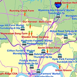
Farms and Farmers Markets in the Cincinnati Region.
Additional Resources:
Herbert Simanson
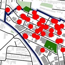
Litter reported in downtown Cincinnati regions.
Additional Resources: